
| You don’t have to be a geography junkie to like this but it might help. Google offers a free download called "Google Earth". Here’s some information about the download in case you’d like to get it at home: http://earth.google.com/. The software is free and it can be downloaded on school networks - contact your tech department if you like it. Google Earth is basically a much more dynamic form of Google Maps which was highlighted in the previous tech tip (#30). Once you have it downloaded you can begin by clicking on the new desktop icon. By the way you'll need to be connected to the internet for this to work and we'd recommend a high speed connection (DSL or cable model for example). Lets start by flying to a school. Type in you school address into the box at the upper left hand area of the screen. For this example I'll be using: “116 Richboro Road, Newtown PA, 18940” Then click the button next to the box and enjoy the ride: 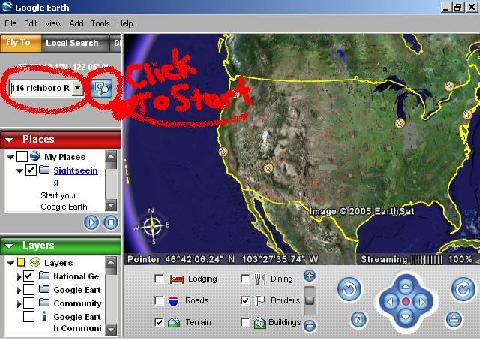 Now to show you a little more of what this program can do try taking their tour. Click on the play button as indicated below: 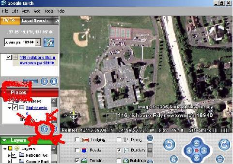 You might not want to put your classroom globes away just yet but you have to admit that this is cool. |
PRACTICE ACTIVITY: Try “flying” to some places you know of or places you could use as part of your curriculum. You can always make the image full screen by going to “View” and selecting “Full Screen” and then taking a screen shot of the image for use in class (CTRL + Print Scrn). Please remember that our students have accessed google earth and many of them find it mesmerizing.
TO KEEP ON LEARNING: If you'd like to learn more about this technology try searching the internet for:
How Google Earth works
Virtual tourism |
More online maps and virtual earth
10:17:00 AM
0
Tags
